|
|
|
|
|
Beltane/Lughnasa Alignments at Prehistoric Sites in UK & Ireland |
Winter Solstice Alignments at Prehistoric Sites with Decorated Stones in UK & Ireland |
Prehistoric Sites
with decorated stones and possible
Winter Solstice alignments
by Martin J. Powell
|
|
In the Northern hemisphere, the winter solstice occurs when the Sun reaches its most Southerly point along the ecliptic (the Sun's apparent path through the constellations). This is the shortest day of the year and the official commencement of winter (in the Southern hemisphere this is the summer solstice, i.e. its longest day and the official commencement of summer).
Due to an effect called precession of the equinoxes, whereby the Earth's axis 'wobbles' in space, in prehistoric times the Sun's declination had a slightly greater value at midwinter (and midsummer) than it does today. The sites listed here are thought to date from the later Neolithic and Bronze Age periods in Britain and Ireland, at which time the Sun's declination at midwinter was around -23�.91. In the current Gregorian calendar, the winter solstice in the Northern hemisphere takes place on 21st or 22nd December.
Whilst the interpretation of decorated stones remains under debate, the following sites, together with those containing alignments to other significant calendar dates, provide some evidence to support the theory that in certain instances they may have held an astronomical symbolism.
The book references shown in the 'Source' column are listed in the 'Bibliography' section below.
|
Site |
County |
Site Type |
Grid Reference |
Alignment Type |
Source |
Note |
|
WALES |
||||||
|
Crick Barrow |
Monmouthshire |
RB |
CS |
Powell 1995, S49-S56 |
||
|
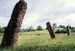
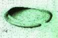
Harold's Stones |
Monmouthshire |
SR |
A3 |
Burl 1993, 256-7 |
1 (Photo) |
|
|
ENGLAND |
||||||
|
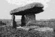
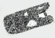
Long Meg & Her Daughters |
Cumbria |
SC |
CO |
Thom 1967, 99 (L 1/7) |
2 (Photo) |
|
|
Duddo Four Stones |
Northumberland |
SC |
CS |
Milligan & Burl 1999, 184 |
3 |
|
|
SCOTLAND |
||||||
|
Rothiemay |
Aberdeenshire |
RSC |
CS |
Burl 1976, 179 |
4 |
|
|
Loanhead of Daviot |
Aberdeenshire |
RSC |
CS |
Milligan & Burl 1999, 42 |
5 |
|
|
Brainport Bay |
Argyll |
SS |
IF |
Ruggles 1999, 29-34 |
6 |
|
|
Ballymeanoch |
Argyll |
SR |
A |
Burl 1993, 175, 248 |
7 |
|
|
Balnuaran of Clava |
Inverness-shire |
CC |
P |
Milligan & Burl 1999, 80 |
8 |
|
|
Monzie |
Perthshire |
KC |
CO |
Burl 1976, 197-8 |
9 |
|
|
IRELAND |
||||||
|
Drombeg |
County Cork |
RSC |
CO |
Burl 1976, 222 |
10 |
|
Site Type
SC - Stone Circle |
SS - Stone Setting |
SR - Stone Row |
RB - Round Barrow |
RSC - Recumbent Stone Circle |
CC - Clava Cairn (passage-grave) |
KC - Kerb-Cairn |
|
Alignment Type
CS - Site (centre) to Stone |
P - Line along tumulus passage |
CO - Site (centre) to Outlier |
A - Alignment of stones |
|
IF - Indicated Foresight (i.e. notch or cleft on horizon) |
A3 - Alignment with 3 stones |
In addition to the above sites, the following stone circle variants, known as 'Four-Posters', also contain cup-marked stones in their South-easterly or South-westerly quadrant, which may have served as indicators of the midwinter sunrise or sunset. However, the astronomy of these sites has not yet been fully assessed (Ruggles 1999, 157). Because of the small sizes of these sites, the precision level of the proposed astronomical alignments is likely to be considerably less than the majority of those listed above.
|
Site |
County |
Grid Reference |
Quadrant of Cupmarked stone |
Source |
Note |
|
WALES |
|||||
|
Four Stones |
Powys |
SW |
Burl 1976, 371 |
11 |
|
|
ENGLAND |
|||||
|
The Goatstones |
Northumberland |
SE |
Burl 1976, 194, 285-6 |
12 |
|
|
SCOTLAND |
|||||
|
Balkemback |
Angus |
SE |
Burl 1976, 354 |
|
|
|
Carse Farm I |
Perthshire |
SE & NE |
Burl 1976, 362 |
13 |
|
|
Cramrar |
Perthshire |
SE |
Burl 1976, 362 |
|
|
|
Lundin Farm |
Perthshire |
SE |
Milligan & Burl 1999, 204 |
14 |
|
NOTES
1. The central pillar of this three-stone alignment has two large cupmarks on its SW face.
2. Alignment is from geometrical centre to the outlying standing stone known as Long Meg. On one face of Long Meg are three carvings; a cup-and-ring mark with a gutter, a spiral and some incomplete concentric circles.
3. Five stones remain of an original circle of eight. The cupmarks are on the inner face of a stone at the SW.
|
|
4. The recumbent stone is positioned at the SW and has 119 cupmarks. Unlike Rothiemay, the majority of recumbent stone circles in Aberdeenshire appear to have their recumbent slabs orientated towards the major Southern moonset (see Note 5).
5. Alignment is from the circle centre to a cup-marked stone positioned to the East of the recumbent slab. The recumbent slab itself is positioned at the SSW of the circle, in line with the major Southern moonset.
6. This peculiar site was discovered and examined in the mid-1970s and mid-1980s. It comprises man-made platforms, standing stones, cup-marked slabs and other features. The alignment in question is from the so-called 'Oak Bank' stone, a recumbent slab situated on a ridge, to a natural outcrop with a single cupmark some 35 metres to the SW.
7. Alignment is to the rising midwinter Sun to the SE. The two inner stones of the four-stone alignment are cup-marked on alternate faces. Burl also suggests that the builders may have intended the rays of the midwinter setting Sun to fall on the SW face of one of the cup-marked stones. The alignment to the NW is to the most Northerly moonset.
8. The site comprises a NE-SW line of three Clava cairns. Two passage-grave entrances face the midwinter setting Sun, which would have shone into their chambers. There are cupmarks in the chamber of the SW tomb and on its Western kerbstone.
9. Alignment is to a 1.8 metre long boulder positioned some 3 metres to the South-west of the kerb. The boulder is decorated with cupmarks, cup-and-ring marks and grooves. A crude causeway connects the boulder to the cairn. A kerbstone on the Eastern side of the cairn is also cup-marked.
10. Alignment is through the recumbent slab at the SW, which has a cupmark carved inside the apparent outline of an axe. Opposite the recumbent are two tall portal stones, which define the axis of the circle along the same alignment.
11. The South-western stone of the Four Stones has three cupmarks on its sloping upper surface, each about 7cm in diameter (see site plan).
12. These four stones may originally have surrounded a cairn.
13. The site is also referred to by the names 'Dull' and 'Weem'.
14. Alignment is to a fallen stone SE of the circle, which has numerous cupmarks.
Copyright Martin J Powell June 2003
BIBLIOGRAPHY
BURL, Aubrey
1976 The Stone Circles of the British Isles, Yale University Press (New Haven & London).
1993 From Carnac to Callanish: The Prehistoric Stone Rows and Avenues of Britain, Ireland and Brittany, Yale University Press (New Haven & London).
MILLIGAN, Max & BURL, Aubrey
1999 Circles of Stone: The Prehistoric Rings of Britain and Ireland, The Harvill Press (London).
POWELL, Martin J.
1995 'Astronomical Indications at a Bell-barrow in South Wales' in the journal Archaeoastronomy, Vol. 26, No. 20, Science History Publications (Cambridge).
RUGGLES, Clive
1999 Astronomy in Prehistoric Britain and Ireland, Yale University Press (New Haven & London).
THOM, Alexander
1967 Megalithic Sites in Britain, Oxford University Press (Oxford).
|
|
|
|
|
|
|
|