|
|
|
|
|
Beltane/Lughnasa Alignments at Prehistoric Sites in UK & Ireland |
Winter Solstice Alignments at Prehistoric Sites with Decorated Stones in UK & Ireland |
Prehistoric Sites
with possible alignments towards
the Beltane/Lughnasa sunrise/sunset
by Martin J. Powell
Although prehistoric alignments towards the May Day/Lammas sunrise/sunset were suggested by Sir J. Norman Lockyer and F. C. Penrose as far back as 1901, it was Professor Alexander Thom who, in the 1960s, proposed an accurate and workable prehistoric calendar. Based on evidence gleaned from his surveys of some 300 prehistoric sites, Thom proposed that the prehistoric year was divided into 16 roughly equal parts, or 'months', based primarily around the solstices and the equinoxes.
The cross-quarter days (also called mid-quarter days) mark the points mid-way in time between the solstices and the equinoxes. These significant seasonal dates were celebrated by the Iron Age Celts of North-western Europe in the festivals of Imbolc (February), Beltane (May), Lughnasa (August) and Samhain (November). Falling either side of the summer solstice, Thom defined the May Day/Lammas dates (i.e. Beltane/Lughnasa) as occurring when the Sun's declination was +16�.67� 0.14 (Thom 1967, 110). In the current Gregorian calendar, this corresponds to dates around 6th-8th May for Beltane and 5th-7th August for Lughnasa (McCluskey 1989, S18).
The following table gives details of British and Irish sites dating from the later Neolithic and Bronze Age periods which are thought to include alignments towards May Day/Lammas. There are undoubtedly many more candidate sites, however the ones listed here are known to have been accurately surveyed and the astronomy thoroughly assessed. The alignments proposed by Thom are taken from Table 8.1 of his 1967 work. His 'Class C' alignments, i.e. those with the poorest indications, are excluded from this list.
The book references shown in the 'Source' column are listed in the 'Bibliography' section below.
|
Site |
County |
Site Type |
Grid Reference |
Alignment Type |
Source |
Note |
|
WALES |
||||||
|
Crick Barrow |
Monmouthshire |
RB |
CS |
Powell 1995, S49-S56 |
||
|
Nant Tarw |
Powys |
SC |
CC |
Thom 1967, 101 (W 11/4) |
1 |
|
|
Moel ty Uchaf |
Gwynedd |
CC |
CC |
Thom 1967, 100 (W 5/1) |
|
|
|
Penmaen-mawr (Druid's Circle) |
Gwynedd |
SC |
CC |
Thom 1967, 100 (W 2/1) |
||
|
ENGLAND |
||||||
|
Stonehenge |
Wiltshire |
SC & H |
SS |
Burl 1987, 145-6 |
2 |
|
|
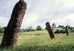
Long Meg & Her Daughters |
Cumbria |
SC |
CC |
Thom 1967, 99 (L 1/7) |
3 (Photo) |
|
|
Barbrook II |
Derbyshire |
SC |
AA |
Burl 1983, 40 |
4 |
|
|
Leaze |
Cornwall |
SC |
CS |
Thom 1967, 100 (S 1/6) |
|
|
|
Craddock Moor |
Cornwall |
SR |
A |
Burl 1993, 98 |
5 |
|
|
Stannon |
Cornwall |
SC |
IF |
Barnatt 1982, 74, 167-70 |
6 |
|
|
SCOTLAND |
||||||
|
Sheldon of Bourtie |
Aberdeenshire |
?RSC |
CO |
Thom 1967, 98 (B 1/8) |
|
|
|
Cauldside |
Dumfries & Galloway |
SC |
IF |
Thom 1967, 98 (G 4/14) |
|
|
|
Callanish VI |
Lewis |
SC |
CC |
Thom 1967, 98 (H 1/6) |
|
|
|
Rueval Stone |
South Uist |
SS |
IF |
Thom 1967, 99 (H 4/4) |
|
|
|
Ross of Mull |
Mull |
SS |
IF |
Thom 1967, 99 (M 2/6) |
7 |
|
|
Learable Hill |
Sutherland |
SC |
A |
Thom 1967, 100 (N 2/1) |
|
|
|
IRELAND |
||||||
|
Beltany Tops |
Co. Donegal |
SC |
SS |
Milligan & Burl 1999, 29 |
8 |
|
Site Type
| SC - Stone Circle |
H - Henge |
| SR - Stone Row |
SS - Standing Stone |
| RB - Round Barrow |
RSC - Recumbent Stone Circle |
| CC - Cairn-circle |
|
Alignment Type
CC - Site (centre) to Site (centre) |
SS - Stone to Stone |
|
IF - Indicated Foresight (i.e. notch or cleft on horizon) |
CS - Site (centre) to Stone |
A - Alignment of Stones |
CO - Site (centre) to Outlier |
|
AA - Axial alignment |
|
NOTES
1. Thom refers to the site as 'Usk River'.
2. Alignment is from Station Stone 91 to 93, two stones of a rectangle of 'Four Stations' positioned just inside the bank of the henge. Today, Stone 91 is prostrate and Stone 93 survives only as a stump, though all four stones were originally upright.
3. Alignment is from the geometrical centre of the flattened circle towards a cairn-circle known as 'Little Meg' 0.8 km distant (NY 576 374).
4. Alignment suggested by Barnatt and cited in Burl, 1983. The cist inside the circle has a cup-marked slab.
5. Alignment suggested in Meyn Mamvro magazine in 1991 and cited in Burl, 1993. The 244 metre long alignment of 85 stones ends at a cairn on Caradon Hill.
6. Alignment is from the centre of the stone circle to sunrise over Rough Tor.7. Also known as Tirghoil standing stone.
8. Alignment is from a tall menhir at the WSW of the stone circle to a cup-marked stone at the ENE of the circle. The name 'Beltany' is derived from 'Beltane'.
Copyright Martin J Powell June 2003
BIBLIOGRAPHY
BARNATT, John
1982 Prehistoric Cornwall: The Ceremonial Monuments, Turnstone Press (Wellingborough).
BURL, Aubrey
1976 The Stone Circles of the British Isles, Yale University Press (New Haven & London).
1983 Prehistoric Astronomy and Ritual, Shire Publications (Aylesbury).
1987 The Stonehenge People, Barrie & Jenkins (London).
1993 From Carnac to Callanish: The Prehistoric Stone Rows and Avenues of Britain, Ireland and Brittany, Yale University Press (New Haven & London).
McCLUSKEY, Stephen C.
1989 'The Mid-Quarter Days and the Historical Survival of British Folk Astronomy' in the journal Archaeoastronomy, Vol. 20, No. 13, Science History Publications (Cambridge).
MILLIGAN, Max & BURL, Aubrey
1999 Circles of Stone: The Prehistoric Rings of Britain and Ireland, The Harvill Press (London).
POWELL, Martin J.
1995 'Astronomical Indications at a Bell-barrow in South Wales' in the journal Archaeoastronomy, Vol. 26, No. 20, Science History Publications (Cambridge).
THOM, Alexander
1967 Megalithic Sites in Britain, Oxford University Press (Oxford).
|
|
|
|
|
|
|
|