|
|
|
|
|
Prehistoric Sites in Wales: |
Page 2 |
Prehistoric Sites in
WALES
by Martin J. Powell
Page 2 of 5
Click on a picture to see a larger image (all pictures will open in a new window).
The abbreviation 'Ast' indicates that the site is included in the archaeoastronomy study of monuments in South Wales.
|
Tinkinswood a.k.a. Castell Carreg Chambered Cairn
County: Vale of Glamorgan (South Glamorgan) Ordnance Survey Grid Ref: ST 092 733 O.S. Map (Streetmap) Satellite Photo (Google Maps) |
The Castell Carreg ("rock castle") was excavated and restored in 1914. The cairn is rectangular, measuring 130 ft (40 m) long by 56 ft (17 m) wide, with a trapezoid chamber at the Eastern end. The chamber measures 16 ft (5 m) by 11½ ft (3.5 m) and it is covered by a massive capstone 23 ft (7.1 m) by 13½ ft (4.1 m). The capstone is one of the largest in Britain, weighing an estimated 40 tons (40,640 kgs).
Excavation revealed the remains of at least fifty people, together with pottery of Neolithic date. A stone-lined pit of unknown purpose is set into the cairn about half way along its length; one theory is that it was used to hold corpses until the flesh had rotted away - a process known as excarnation - after which the bones were placed inside the chamber. Finds from the tomb excavation were recently radiocarbon-dated to around 3700 BC.
Following excavation a pillar was introduced into the chamber to add support to the capstone, in which a large crack had developed. The pointed corners of the 'horns' at the eastern end of the cairn are quite unlike most other tombs of this particular type and are likely to be the result of the excavator having incorrectly envisaged the original form of the monument. The 'herring-bone' style of drystone walling seen in the forecourt was added during restoration in order to distinguish it from the original walling seen elsewhere along the cairn.
The source of the stones used to built the tomb has often been assumed to be a location known as The Quarry in a field some 330 ft (100 m) to the East of the long cairn. However, an examination of the area in 2011 failed to find any evidence of Neolithic activity. The source of the stones used to construct the tomb is, therefore, unknown.
An impression of the original appearance of the tomb is shown in a painting of a burial ceremony at Tinkinswood (ca. 1939) by the artist Alan Sorrell (1904-1974).
A megalithic structure located in the adjacent field called The Stable (ST 093 732) to the East of Tinkinswood chamber has long been considered a possible collapsed Neolithic burial chamber. Excavation of the site in 2011 finally settled the mystery: it is a Bronze Age round barrow, measuring about 16 ft (5 m) in diameter. No traces of a prehistoric burial had survived, although a Roman burial had later been inserted into the mound. A large slab lying on top of the mound - once thought to have been a chamber capstone - was determined to be the result of field clearance in the 19th century [Ast]
|
|
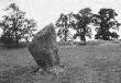
Maen Ceti a.k.a. Arthur's Stone Chambered Cairn
County: West Glamorgan O.S. Grid Ref: SS 491 905 O.S. Map (Streetmap) Satellite Photo (Google Maps) |
This crudely-formed chamber stands on the exposed moorland of Cefn Bryn on the Gower peninsula. The boulder which forms the capstone is 13 ft (4 m) long and over 6½ ft (2 m) thick. It would originally have weighed about 40 tons (40,640 kgs) before a section broke off (right of picture). The boulder was probably always in this position and was under-pinned by the tomb builders with at least ten smaller upright blocks, set in the crude form of a chamber.
The cairn around the tomb is circular, approximately 75 ft (23 m) in diameter. It is unlikely that the cairn material ever completely covered the tomb. The site has not been excavated [Ast]
|
|
Tarrendeusant Pagan Cult Site
County: Mid Glamorgan (Rhondda Cynon Taff) O.S. Grid Ref: ST 052 872 O.S. Map (Streetmap) |
Located within a small forest, this is considered to be a pagan cult site, possibly dating from the Iron Age period. At least eight human faces are carved into a vertical rock face next to a natural spring. One particular figurine appears to have a human head and torso but a fish-like tail. Due to their proximity to the spring it is likely the cult was related to water worship. The carvings are well preserved, but modern graffiti surrounds them.
The name tarren deusant translates from Welsh as "rock of the two saints".
Another view of the main rock can be seen here.
|
|
Sweyne's Howes North Chambered Cairn
County: West Glamorgan O.S. Grid Ref: SS 421 899 O.S. Map (Streetmap) |
On the East facing slope of Rhosili Down are two extensively robbed burial chambers from the Neolithic age. The Northern chamber stands at the Western end of an oval cairn measuring 59 ft (18 m) by 42 ft (13 m). The chamber is ruinous and opens to the North. It has two tall portals and a backstone which has fallen inwards. The capstone has slipped and rests on the portal stones.
The Sweyne's Howes South tomb is about 330 ft (100 m) away and is very ruinous. The cairn measures 69 ft (21 m) by 49 ft (15 m) but no chamber survives.
The name 'Sweyne's Howes' derives from a local legend which says that a Viking named Sweyne is buried here. 'Howe' is a Norse word for 'mound'.
About a half-mile (0.7 km) to the South, high up on the ridge of the Down are a group of round cairns dating from the Bronze Age; one example can be seen on Page 5.
|
|
Saith Maen NW (Craig-y-nos) Stone Row
County: Powys (Brecknockshire) O.S. Grid Ref: SN 833 154 O.S. Map (Streetmap) |
The Saith Maen ("seven stones") form an alignment about 31 ft (9.5 m) in length. Five stones are still upright, standing between 2 ft (0.7 m) and 5 ft (1.5 m) high. The two fallen stones are 9½ ft (2.9 m) and 7 ft (2.2 m) long. The Northern end of the row stands only metres from the edge of a deep solution hollow (sink hole), one of several which are present in the area.
The row is aligned on a bearing of ca.25-205 degrees. It has been suggested that the row might have been orientated toward the Cerrig Duon stone circle situated 3.4 miles (5.5 kms) to the NNE (see Page 1).
The row is suffixed 'NW' in order to distinguish it from two other sites of the same name in Powys county; a prehistoric stone row near Llanwrthwl at SN 949 603 and a natural boulder at SN 861 146 [Ast]
|
|
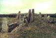
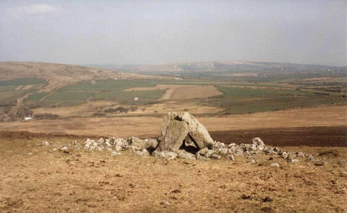
Ffostill North a.k.a. Ffostyll Chambered Cairn
County: Powys (Brecknockshire) O.S. Grid Ref: SO 179 349 O.S. Map (Streetmap) |
One of two long cairns in close proximity to each other, the Northern site has three small, ruinous chambers set within a long mound about 134 ft (41 m) long by 72 ft (22 m) wide. The chamber pictured is at the Eastern end, the most visible of the three. The other chambers are largely hidden within the mound. The site was scantily excavated in 1923, when human remains were found, together with those of horse, dog, ox and pig. The remains of at least eleven individuals, including two children, were found in the other two chambers.
Ffostill South long cairn, situated some 230 ft (70 m) to the SSW, has at least one chamber, positioned at the Northern end of the mound. The remains of numerous individuals were found between 1921-3 [Ast]
|
|
Ty-Mawr Standing Stone
County: Anglesey (Ynys Môn) O.S. Grid Ref: SH 254 810 O.S. Map (Streetmap)
|
A fine example of a standing stone can be found in the middle of a field a short distance from the A55 trunk road just outside Holyhead. The Ty-Mawr monolith is 8 ft 10 in (2.7 m) tall, 3 ft 11 in (1.2 m) wide and 1 ft 4 in (0.4 m) thick. Its long axis is orientated approximately NE-SW.
Without excavation, the date and function of these enigmatic monuments cannot be known; modern-day archaeologists often describe them as having served a 'funerary and/or ritual function'. Alternatively, it might simply be a cattle-rubbing stone, erected here by a farmer just a few centuries ago!
The Trefignath Neolithic chambered cairn is about 0.4 miles (0.6 km) to the South-east of the monolith (see Page 4).
|
|
Bedd Gorfal Stone Circle / Cairn Circle
County: Gwynedd (Merionethshire) O.S. Grid Ref: SH 613 311 O.S. Map (Streetmap) |
This small circle lies on a rocky hillock to the East of Harlech town. Owing to its small size, it may be the remnants of a cairn-circle, the inner region having been robbed of stone over the centuries, probably for the construction of cottages and field-walls.
The circle overlooks the picturesque Snowdonia mountain range.
|
|
Penywyrlod (Llanigon) a.k.a. Penywrlod Chambered Cairn
County: Powys (Brecknockshire) O.S. Grid Ref: SO 225 398 O.S. Map (Streetmap) |
The main chamber is located at the Eastern end of a circular or oval mound 59 ft (18 m) long by 29 ft (9 m) wide. The chamber is rectangular, measuring 6½ ft (2 m) by 3 ft (1 m), orientated ENE-WSW. A smaller, ruinous chamber is embedded within the mound towards the Western end. The chambers are built of sandstone slabs and both have lost their capstones.
The site was excavated in 1921. The main chamber had been filled with stones and black earth to a depth of 4 ft (1.2 m). It contained the remains of some twenty individuals.
The chamber stones were apparently reset following the excavation, so their present arrangement may not be a wholly accurate representation of the chamber's original form [Ast]
The site should not be confused with that of Penywyrlod (Talgarth), a long cairn sited some 7 miles (11 kms) to the South-west (see Page 1).
|
|
Dyffryn Ardudwy Chambered Cairn
County: Gwynedd (Merionethshire) O.S. Grid Ref: SH 589 229 O.S. Map (Streetmap) |
A classic example of a type of burial chamber known as a portal dolmen, this chamber is one of two which are contained within a large rectangular cairn measuring 92 ft (28 m) long by 49 ft (15 m) at its widest. This particular chamber is towards the western side of the cairn, and was probably constructed in its own oval-shaped cairn before the eastern chamber was added and the cairn material extended. The site was excavated in 1962.
Rock art, in the form of circular hollows (cupmarks) and a series of grooves, are present on the North and South portal stones of the western chamber.
A reconstruction painting of the two chambers by David Gunning can be seen at the National Museum Wales website.
|
|
Ynys-Hir Stone Circle
County: Powys (Brecknockshire) O.S. Grid Ref: SN 921 383 O.S. Map (Streetmap) |
This circle is located on Mynydd Eppynt, within the Sennybridge Military Training Area. Excavated in 1940, the circle is in a remote area overlooking the Nant Bran Valley. The circle is 56 ft (17 m) in diameter and originally comprised 27 stones, of which 11 are now visible. An arrangement of natural stones, positioned at the South-east of the circle, appear to have been left in situ by the circle builders, the remainder of the circle having been constructed around them.
The wrecked car seen in the picture was riddled with bullet-holes and had clearly been used by the military for target practice! [Ast]
|
Prehistoric Sites in Wales: |
Page 2 |
|
|
|
|
|
|
Copyright Martin J Powell 2001-2015
")
")
")
")
 stone row, Powys (Photo: March 1989)")
")
")
")
")
")
")